Dec 18, 2023
Introduction to Photogrammetry: Unlocking the World of Precise Mapping
This article explores the fundamentals of photogrammetry, its principles, and its diverse applications in the creation of both 2D and 3D maps. By understanding the basics of photogrammetry, we can appreciate its significance in the modern world and its role in transforming the way we perceive and navigate our environment.
The Significance of Photogrammetry
Precise Mapping: Photogrammetry enables the creation of highly accurate and detailed maps, enhancing our understanding of geographic features and their spatial relationships.
Cost-Effective Surveying: Photogrammetry offers a cost-effective alternative to traditional surveying methods, reducing the need for extensive fieldwork and physical measurements.
Rapid Data Collection: Photogrammetry allows for the rapid acquisition of data, making it a valuable tool for emergency response, urban planning, and environmental monitoring.
Visualization: 3D modeling through photogrammetry aids in visualizing and analyzing geographic data, improving decision-making in various domains.
Principles of Photogrammetry
Overlap and Stereo Imaging: Photogrammetry relies on the principles of overlap and stereo imaging, where multiple overlapping images are captured from different angles, allowing for the reconstruction of three-dimensional information.
Parallax: Parallax, the apparent shift in position of objects when viewed from different perspectives, is crucial in determining depth and spatial relationships in photogrammetry.
Ground Control Points (GCPs): GCPs are known points on the Earth's surface with precisely surveyed coordinates. They serve as reference points for georeferencing and scaling photogrammetric data.
Aero Triangulation: Aero Triangulation (AT) is the determination of horizontal and/or vertical coordinates of points on the ground, from measurements performed using overlapping aerial photographs and from already known coordinates of points on the ground.
Bundle Adjustment: Bundle adjustment is the mathematical optimization process that refines the spatial relationships between images and GCPs, improving the accuracy of photogrammetric models.
Applications of Photogrammetry
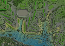
Topographic Mapping: Photogrammetry is widely used in creating topographic maps, which provide detailed information about the Earth's surface, including elevation, land use, and infrastructure.
Aerial Photography: Aerial photogrammetry is employed for mapping large areas, monitoring land use changes, and assessing environmental conditions.
3D Modeling: Photogrammetry is crucial in 3D modeling for urban planning, archaeological site documentation, and cultural heritage preservation.
Disaster Management: Photogrammetry aids in rapid disaster assessment, helping first responders and relief organizations make informed decisions in the aftermath of disasters.
Cartography: Photogrammetry supports the creation of various types of maps, including orthophotos (geometrically corrected aerial images), digital elevation models (DEMs), and 3D city models.
Best Practices in Photogrammetry
Quality Imagery: Ensure high-quality imagery with proper camera calibration, appropriate sensor settings, and controlled lighting conditions.
GCP Selection: Select GCPs carefully, distributing them evenly across the study area for accurate georeferencing.
Survey Accuracy: Maintain a high level of survey accuracy in GCPs and camera positions for precise mapping.
Software and Hardware: Utilize modern photogrammetry software and hardware tools for image processing, 3D reconstruction, and map creation.
Data Validation: Verify the accuracy of photogrammetric results through field surveys, ground truthing, and consistency checks.
Impact and Benefits of Photogrammetry
Precision: Photogrammetry enables highly precise mapping, supporting decision-making in various fields, from urban planning to resource management and in all phases of civil engineering design.
Cost-Effective Mapping: The cost-effectiveness of photogrammetry makes it a valuable tool for large-scale mapping projects.
Rapid Data Acquisition: Photogrammetry accelerates data acquisition, particularly important in emergency response and disaster management.
Visualization and Analysis: The creation of 3D models through photogrammetry enhances visualization and spatial analysis, aiding in understanding complex geographic data.
Conservation and Preservation: Photogrammetry is essential for documenting and preserving cultural heritage, archaeological sites, and historical landmarks.
Take a moment to view some of GEOD’s photogrammetry projects:
- Adaptive Traffic Signal Final Design
- Design Services for Replacement of Turnpike Street Numbers E11295A and E112.95B OPS T3826
Contact GEOD Corporation for Cutting-Edge Photogrammetry Solutions
Photogrammetry is a versatile and indispensable tool in the world of mapping and surveying. Its principles, applications, and best practices make it an asset for various domains, from topographic mapping to disaster management and cultural heritage preservation. The precision, cost-effectiveness, and rapid data acquisition capabilities of photogrammetry contribute to its significance in modern cartography, enabling us to explore, analyze, and preserve our world with unparalleled accuracy and efficiency.
For cutting-edge photogrammetry solutions tailored to your specific needs, we invite you to contact us. Our team of experts is ready to discuss how our advanced technology and expertise can enhance your mapping and surveying projects.
Reach out to us today to explore the possibilities that GEOD can off in the realm of photogrammetry.