Drone Survey for Pile Volume Study for Quest Diagnostics Laboratory Site
MFS (formerly GEOD) conducted a sUAS (drone) survey for assessing dirt and debris piles to facilitate their removal as part of the site development for Quest Diagnostic’s largest facility.
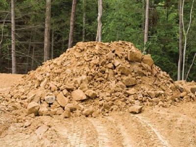
After MFS (formerly GEOD) personnel conducted an initial site inspection, it was determined that the most efficient method for calculating pile volumes would be through drone imagery capture. Given the ongoing activity at the site, it was imperative to collaborate with construction crews without disrupting their operations. Upon arrival, MFS’s crew positioned 10 temporary ground control targets around the perimeter of the piles, which were subsequently surveyed using GPS technology. The drone flight was strategically scheduled for mid-day, during lunchtime, to minimize interference with equipment and construction activities in and around the piles. The site was surveyed in both north-south and east-west directions, with significant overlap, completing comprehensive coverage in less than 30 minutes. Immediately on-site, MFS conducted quality assurance checks on the captured imagery to ensure proper exposure and focus.
MFS’s survey department processed the GPS coordinates for the ground control points, while the drone imagery underwent calibration and processing. This process resulted in the creation of a highly accurate 3D model (digital surface model) of the site’s piles. The boundaries of individual piles, as defined by the contractor, were identified and outlined within the 3D model. Volume calculations were then computed based on the triangulated base elevations of the surrounding terrain. Subsequently, MFS generated a volume report for the client, providing information on pile locations, their respective sizes, cut/fill volumes, total volume, and estimated errors for each pile.
- Owner: Quest Diagnostics
- Services: Drone