Feb 29, 2024
LiDAR Data Accuracy and Precision Redefining Surveying Standards
Below we explore the accuracy and precision of LiDAR data and compare it to traditional surveying methods. Understanding the capabilities and limitations of LiDAR is critical for leveraging this technology to its full potential and appreciating its transformative impact on modern surveying and mapping.
The Significance of LiDAR Data Accuracy and Precision:
Surveying and Mapping: Accurate and precise LiDAR data is essential for surveying and mapping applications, providing detailed information about the Earth’s surface and structures.
Engineering and Infrastructure: LiDAR plays a critical role in engineering and infrastructure projects, ensuring the precise measurement of elevation, distances, and spatial features.
Environmental Monitoring: LiDAR is used in environmental studies to monitor terrain changes, vegetation growth, and natural disasters.
Disaster Management: Accurate LiDAR data supports disaster response efforts by providing real-time information about affected areas and damage assessment.
Cultural Heritage Preservation: LiDAR aids in the documentation and preservation of cultural heritage sites and archaeological findings with high precision.
Accuracy and Precision in LiDAR Data:
Accuracy: Accuracy in LiDAR data refers to how closely the measured values align with the true values. Factors influencing accuracy include the instrument’s calibration, data processing, and the quality of the reference points used for georeferencing.
Precision: Precision relates to the consistency and repeatability of measurements. LIDAR data is inherently precise due to the speed of light and the technology’s ability to measure distances with great accuracy.
Comparing LiDAR to Traditional Surveying Methods:
Speed: LiDAR is significantly faster than traditional surveying methods such as total station or GPS, enabling the rapid collection of large datasets.
Accuracy: LiDAR typically offers higher accuracy due to its direct measurements of distances, while traditional methods may introduce errors through manual measurement and instrumentation limitations
Automation: LiDAR systems are automated and can collect data continuously, reducing the potential for human errors that can occur with traditional surveying methods.
Range: LiDAR can capture data from much greater distances, even in challenging or hazardous terrain, making it suitable for a broader range of applications.
Data Density: LiDAR provides a higher data density, capturing more points per unit area, which is beneficial for detailed topographic mapping and 3D modeling.
Best Practices for Ensuring LiDAR Data Accuracy and Precision
Calibration and Quality Control: Regular calibration and quality control checks of LiDAR equipment are essential to maintain accuracy and precision.
Ground Control Points (GCPs): The use of highly accurate GCPs is crucial for georeferencing LiDAR data and ensuring its alignment with real-world coordinates.
Data Processing: Rigorous data processing, filtering, and point cloud classification are necessary to improve the accuracy and precision of LiDAR data.
Sensor Configuration: Proper sensor configuration, including laser beam angle, pulse repetition rate, and scan patterns, impacts data accuracy and precision.
Field Survey: Combining LiDAR data with ground surveys can further enhance data accuracy and precision, especially in challenging environments.
Impact and Benefits of LiDAR Data Accuracy and Precision
Improved Decision-Making: Highly accurate and precise LIDAR data enables more informed and confident decision-making in surveying, engineering and environmental monitoring, and disaster management.
Cost Savings: By reducing the need for repeat surveys and minimizing errors, LiDAR contributes to cost savings in various applications.
Rapid Data Acquisition: LiDAR’s speed and precision facilities rapid data acquisition, particularly important in emergency response and time-sensitive projects.
Conservation and Preservation: LiDAR is invaluable for the documentation and preservation of cultural heritage and natural resources with unparalleled precision.
Innovation and Advancement: LiDAR data accuracy and precision drive innovation, opens new possibilities in fields such as autonomous vehicles, urban planning, and infrastructure development.
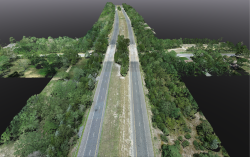
Take a Moment to View Some of GEOD’s LiDAR Projects:
Central Business District Tolling Program Infrastructure and Toll Collection System
Route 55 Over West Oak Rd (Couty Route 681)
Elevate Surveying Excellence with GEOD’s LiDAR Solutions
LiDAR technology has redefined surveying standards by providing unmatched accuracy and precision in geospatial data. Understanding the significance and capabilities of LiDAR in comparison to traditional surveying methods is crucial for unlocking its full potential. The speed, accuracy, and precision of LiDAR data make it an asset in a wide range of applications, from surveying and mapping to engineering, environmental monitoring, and cultural heritage preservation. By embracing and maximizing the capabilities of LiDAR, we can revolutionize our approach to data acquisition and analysis, ultimately advancing our understanding of the world around us.
For state-of-the-art LiDAR solutions tailored to your specific surveying needs, consider partnering with GEOD.
Contact us today to explore how our expertise and cutting-edge technology can enhance the precision and efficiency of your surveying project, ensuring unparalleled accuracy in geospatial data collection and analysis.